


Reconstruction of Marion-Wareham bridge creates concerns over its height, the estuary’s health and traffic safety
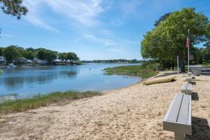
 The bridge between Marion and Wareham rests on a causeway, or an island that supports part of the bridge. Photos by: Patrick Lester
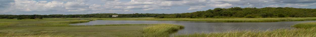
 Taller boats struggle to get under the low bridge, especially at high tide.
The bridge between Marion and Wareham rests on a causeway, or an island that supports part of the bridge. Photos by: Patrick Lester
Taller boats struggle to get under the low bridge, especially at high tide.
Taller boats struggle to get under the low bridge, especially at high tide.
The bridge between Marion and Wareham rests on a causeway, or an island that supports part of the bridge. Photos by: Patrick Lester
Taller boats struggle to get under the low bridge, especially at high tide.
MassDOT plans to rebuild the bridge connecting Marion and Wareham along Route 6. However, community members and a local business owner have concerns about the bridge’s design. They want the bridge’s causeway, or center island, to be removed to increase water flow, and they want the height of the bridge to be raised to allow more boats underneath.
Additionally, some residents of Briarwood Beach, the neighborhood immediately next to the bridge on Wareham’s side, are concerned that construction will make it difficult and dangerous for residents to enter and exit Briarwood Road.
The existing bridge was built in 1929 and widened in 1957. MassDOT’s project description says the bridge is “structurally deficient, functionally obsolete, and critical.”
The project, which is paid for using state and federal funding, will also add a shoulder, widen the lanes and widen the sidewalks. MassDOT estimates construction will take two-and-a-half years to complete.
“Noxious, silty muck”
The Marion-Wareham Bridge runs across the Weweantic River, but much of the bridge’s roadway rests on top of a small island in the middle of the bridge, which constricts the river’s flow.
Just north of the bridge sits the Wareham Marina, owned by oyster farmer Daniel Ward, who has a doctorate in Marine Biology.
As a business owner, Ward said he should only care about the height of the bridge, becuase a higher bridge would increase the number of customers able to access his marina. However, as a community member, the health of the river is his primary concern.
Ward said removing the bridge’s center island will improve the health of the river by flushing out excess nitrogen in the water.
“There’s once-in-a-lifetime times that you get a chance to make this kind of change,” Ward said. “If we don’t have the bridge design proper now, there’s not going to be another chance to fix this for decades.”
He said the area north of the bridge has historically been polluted with excess nitrogen from septic systems, creating an overabundance of nutrients that harms the natural environment.
“If they would get rid of that island… The river would be brought back to health instead of this noxious, silty muck,” Ward said.
Now that many communities near the Weweantic have switched from septic tanks to a sewer system, Ward said there’s less nitrogen polluting the area, but there’s still enough to cause damage to the ecosystem.
He contends that increased water flow would flush out more nitrogen and improve the water quality and health of the estuary, which is a region where fresh and saltwater meet.
Since 2001, the Massachusetts Department of Environmental Protection has been working on the Massachusetts Estuaries Project, which assesses nitrogen loads in coastal estuaries and evaluates improvement methods.
“There’s a big push from MassDEP to improve estuaries,” Ward said. “The town did their part [by adding sewer lines], and DOT isn't willing to do the other piece.”
MassDEP Press Secretary Edmund Coletta said in an email that the department has yet to collect data on the Weweantic River near the bridge, so “it is too early to determine whether removing or changing the island will provide a significant benefit to water quality.”
Garry Buckminster, director of the Wareham Department of Natural Resources, said that MassDOT asked him to make a recommendation on the bridge design. He recommended both removing the island to help water flow and raising the bridge.
“If they’re going to make [the bridge] better, they should make sure they're making it [stand] up to future progress,” Buckminster said.
In a statement to Wareham Week, MassDOT said the existing opening under the bridge “is sufficient to allow for adequate tidal flushing.” The department also said removing the island would “increase the extent and severity of upstream flooding during storm events.” The department won’t rule out removing the island, but it “does not intend to make any modifications to the causeway for the previously stated reasons.”
“Every other piece of information I’ve seen that’s not from DOT has said the opposite of that,” Ward said. He said that the river north of the bridge has more nitrogen, less dissolved oxygen and less water clarity than the area south of the bridge, as reported in the Buzzards Bay Coalition’s Bay Health Index.
Raising the bridge
The existing Route 6 bridge hovers relatively close to the Weweantic River water line — at high tide, there’s around five feet of space.
“I’ve talked to several people and the first thing out of their mouth when talking about the bridge is to raise the height,” said Briarwood Beach resident Edward Pacewicz.
Pacewicz said he doesn’t see why it would be an issue to raise the height of the bridge, “at least three to four feet,” if MassDOT is replacing it anyway.
Residents in the region with larger boats are either unable to drive underneath the bridge, or have to time their entrance correctly with the tides.
That’s especially an issue for Ward. With a higher bridge, more boats could access fuel and services at the Wareham Marina.
“I’d love for the bridge to be raised, but that’s not going to happen,” Ward said.
Ward said that he has been in touch with MassDOT for the past five years, and in that time, he has seen three different project managers take over the design. He said he’s tried to get all of them to raise the bridge, but they’ve continually said they’re not planning to.
In a statement to Wareham Week, MassDOT said the current design would raise the bridge by 1.6 feet. The department also said that the height is not finalized and “MassDOT will take input from waterway users into account, along with other factors such as the various existing site constraints.”
In response to the plan to raise the bridge by 1.6 feet, Ward said he “can’t imagine it’ll be significant” but “every little bit helps.” In an ideal world, the bridge would be raised closer to 15 or 20 feet, he said.
Planning for traffic safety
During construction of the new bridge, one-lane traffic will be maintained in each direction, according to MassDOT’s project description.
“No one that I talked to realized that they were going to be cutting down the lanes crossing the bridge,” Pacewicz said. “If they put that [lane] restriction past the entrance to Briarwood, you’re going to have a hell of a situation.”
Select Board member Tricia Wurts said the exit from Briarwood Road to Route 6 is already dangerous and the view is partially blocked.
“What [is MassDOT] going to do to ensure that people can get in and out of Briarwood safely?” Wurts asked.
Pacewicz said the town could potentially open up the old, closed-down segment of Route 6 that runs parallel to the current Route 6 and is currently connected to the parking lot of the Kaleidoscope of Dance and Gymnastics school.
“If the town were to fix that road, it would give residents another way to exit and enter,” Pacewicz said.
MassDOT has said they “will develop temporary traffic control plans that will meet construction work zone safety standards for all roadway users.”
Event Date